MANGEL-CORA WELLS
This is the page from the September 29, 1950 Aruba Esso News. It is not very clear and when blown up any larger it becomes completely un-readable so I typed out the story and the photo captions for anyone interested in reading the text.
Click on the article below to return to the page about the Mangel Cora well
MANGEL CORA WELL STORY FROM ARUBA ESSO NEWS
One thousand years from today, conditions ma be entirely c hanged in Aruba. The seacoast may be shaped differently; the roads, the homes, the building may be all new. If, for instance, the oil resources of Venezuela are exhausted by that far distant time, the importance of Lago to Aruba may be just a memory. But the people will still be getting water from Mangel Cora Well.
In terms of centuries, Mangel Cora is the most permanent improvement Lago has given to Aruba. No matter what the economy of the island, fresh water is vital to Aruba. And the construction of the well will provide a never ending source of fresh water….so long as it continues to rain.
Much of the rain that falls on Aruba runs into the sea. In a few places, because of the natural formations of the land, it is trapped by hard layers of rock under the coral and held temporarily in storage. Probably that largest of these developed natural “reservoirs” is found near Colorado Point to the east end of the island.
To the average person the ground in this section looks like land anywhere else in Aruba. When rain falls, it quickly soaks into the pours coral and disappears. But there is a difference!
Deep under the coral from Colorado Point to the commissary are large layers of granite rock forming a huge basin about a mile long and a mile wide. The area works just like a sponge on a dinner plate….the coral collects water like a sponge….the granite keeps the water from flowing into the sea to quickly. Lago engineers estimate that the formation collects rain water from a square mile and can hold more than 2,500,000 barrels of fresh water. (Note being oil engineers they estimate the quantity in barrels not gallons.)
Before the dawn of history natural springs existed in this basin area. These springs were overflowing during the rainy seasons, but were probably dry during other parts of the year.
As civilization came to Aruba, those springs were used and improved upon by digging wells. And in early Aruban times, windmills pumps were installed to get the water out of the ground.
Ten of these windmills wells were in operation in the “Mangel Cora Basin” area when Lago first arrived. (This area is bounded by Colorado Point, the hospital, hospital road, colony commissary, the Community Church and the lagoons.)
When the refinery was being built, more fresh water was needed than the windmill pumps could supply. (The output of all the wells was collected in a small piping system and delivered through a single steel line to the old stone reservoir near the present M & C shops.)
Mangel Cora well (one of ten) had proved to be the only consistent producer of acceptable water. But it could not produce enough. When to much water was drawn out, sea water flowed into the well. Except after heavy rains, the average sample was about one third sea water.
Several methods were used to improve this well, and over the years have boosted its supply of fresh water from 1,000 barrels a day or less to more than 5,000 barrels a day. And the improvements are permanent. Mangel Cora will yield water for Aruba indefinitely.
Lago used the same methods which worked well in Europe, Southern California and the other states, the Hawaiian Islands, and other Pacific islands. One of these is the “skimming” tunnel which runs out from the bottom of the well under the ground at sea level. This increases the area that water can be pumped from and acts like many well instead of just one.
By the end of 1930, all the ten wells except the Mangel Cora were abandoned. The present pump station had been built and a 200 foot water collecting tunnel was in service. This tunnel has been extended through the years until now it runs nearly half a mile under the coral.
Early in the work it was found practical to drill holes and pump a concrete mixture into the coral to form an underground dam or “grout line” between the tunnel and the ocean. The concrete helps to fill the holes in the pours coral and act as a barrier to water seepage from the basin to the sea.
The average height of the tunnel is about 7 feet 6 inches; the average width, 4 feet, 6 inches. Warm water (from 89 to 90 degrees) fills the tunnel a little higher than knee level. The floor of the tunnel is rough and uneven; the walls are yellow-white coral. Lago engineers who check the Mangel Cora well at regular intervals belong to the brotherhood of “Moles”, for there are not lights except for air shafts about every 200 feet.
All of the work on Mangel Cora well isn’t done “in the dark” however. A great deal has been learned about the formation of the land in the area through testing and exploratory drilling.
Today more exploratory drilling is going on north of the tunnel. Old wells and minds are being opened; test wells are being drilled. This will give more facts about the location of the granite rock, the thickness of the coral, and the quality of the ground water in that section.
The Mangel Cora ground water system may be extended to tap over more sources of water. But whether or not additional ground water is found, the present tunnel is a permanent contribution to Aruba’s welfare. For a great many years in the future it will be used to collect vital fresh rain water for the island.
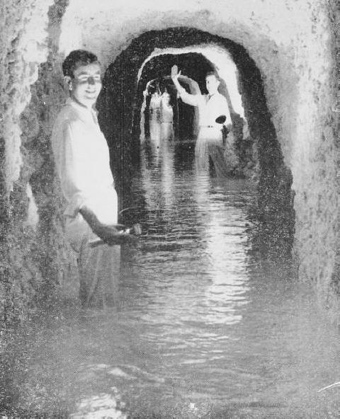
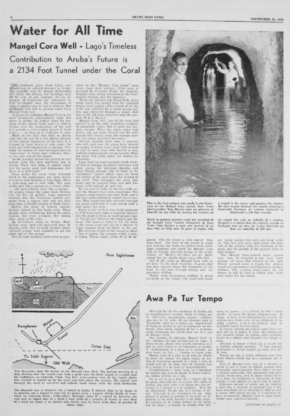
PHOTO CAPTION
This is the first picture ever made in the blackness of the Mangel Cora tunnel. Esso News photographer Tom Boylan took six pictures of himself on one film by setting his camera on a tripod in the water and opening the shutter. He then waded through the tunnel, shooting a hand held flash gun at various intervals to illuminate a 250 foot stretch.
CAPTION UNDER DRAWINGS
Two diagrams show the layout of the Mangel Cora Well. The bottom drawing is a map showing how the tunnel runs from a point near the little lagoon to a point near the lighthouse on Colorado Point. Top left: cross section view of the tunnel shows how rainfall is soaked up by the coral and held above the granite. The tunnel runs through the coral at sea-level and collects fresh water